x100(h)")
")
x150(h)")
x768(h)")


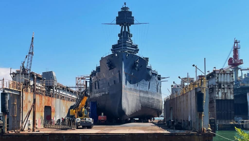
The last surviving Dreadnought-class battleship, USS Texas, is being painstakingly restored in Galveston, Texas. In the course of the work, a World War II operations map was discovered on a cabin wall, having been painted over and later cut into. Described here are the careful steps taken by Ariane Roesch and Zak Miano, who own OnAim Conservation, to fully reveal what remained of the map, rectify the damage and restore it as best possible using modern materials to its original state.
Commissioned in 1914, the battleship USS Texas is credited with the introduction and innovation in gunnery, aviation and radar. It is the last surviving dreadnought and the only battleship still in existence that fought in both World War I and World War II. It is currently undergoing a major refit by Gulf Copper in the US after the shipyard retrieved and purchased a large floating drydock that had been sunk, broken over its length and cut in half during salvage in the Bahamas.
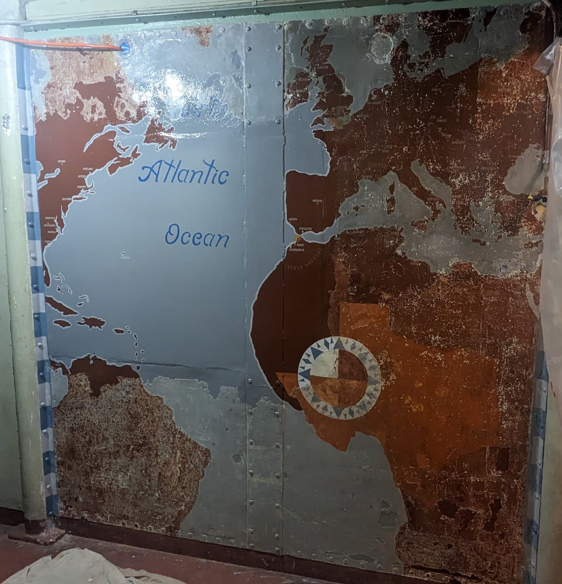
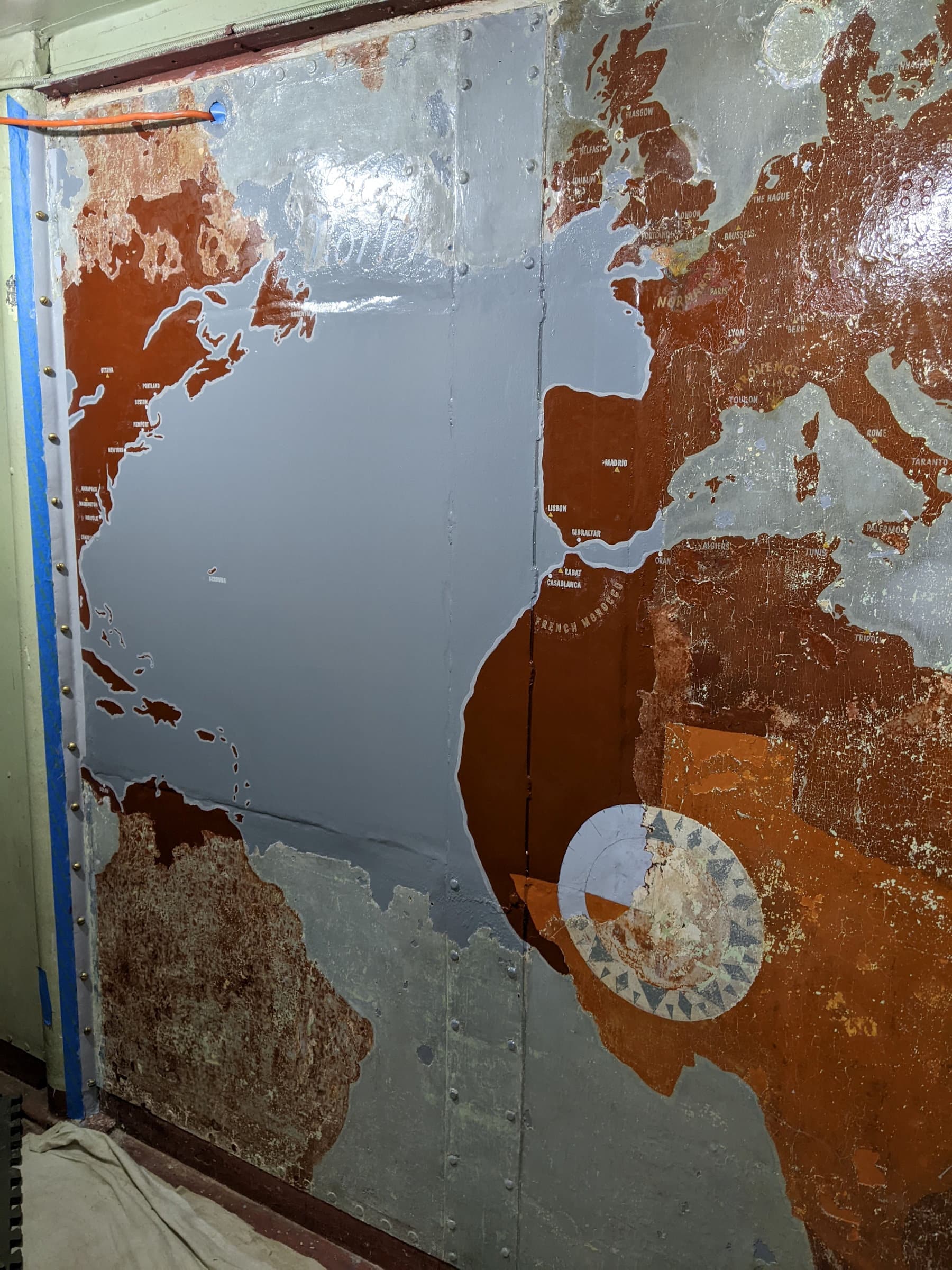
 The approximately 8ft x 8ft (2.4 x 2.4m) map of the WWII Atlantic theatre was painted on a bulkhead in the captain’s cabin after September 1944 (based on references in the map). It shows the ports of call USS Texas made during WWII (white dots with anchors in them), where she performed shore bombardment (noted by little explosions), national capitals (yellow triangles), and a few surprise discoveries as the map was conserved.
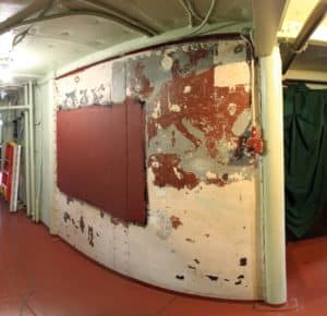 Some time after 1966, which is when the only known historic photo of the map was taken, the map, along with the rest of the captain’s cabin, was painted white. That act was not great, but not terrible either. What was truly terrible is that a window was cut into the bulkhead right in the middle of the map some time in the late 1970s, after the map and compartment were painted white. The Battleship Texas Foundation believes that because the map had been painted over and knowledge of the map lost, those who made that decision did not know it was there.
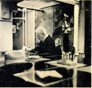 Fast forward to around 2000, when the map began to reveal itself as the white paint began to flake off and the map was rediscovered during the planning for the captain’s cabin restoration. When the captain’s cabin was restored, the window was welded up and the map was partially uncovered, exposing the Mediterranean and most of Europe. In 2009, the 1966 picture of Chief McKeown with the map in the background was discovered, which spurred a lot of excitement about what possibly survived. However, due to budgetary constraints no real conservation treatments could be carried out on the map.
The map then sat partially uncovered and untouched until last summer. In partnership with TPWD (Texas Parks & Wildlife Department) Cultural Resources, OnAim Conservation was hired to stabilise the remaining paint on the bulkhead, just prior to the tow to Galveston. This initial step preserved what remained and protected it from any vibrations from the tow and/or shipyard work.
Conservation procedures
The restoration of the Atlantic theatre map in the captain’s quarters was completed in three phases over the course of a year and a half, starting when the battleship was still at its old location by the San Jacinto monument in Texas and completed after its journey to drydock in Galveston for repair.
Phase I: Stabilisation
Before beginning the first phase, which was to stabilise the map in its current state, the captain’s cabin was first cleaned and wiped down to prevent dust accumulation. An AC unit was also installed to regulate the temperature surrounding the map wall. Once the work area was prepared,
Fast forward to around 2000, when the map began to reveal itself as the white paint began to flake off and the map was rediscovered during the planning for the captain’s cabin restoration. When the captain’s cabin was restored, the window was welded up and the map was partially uncovered, exposing the Mediterranean and most of Europe. In 2009, the 1966 picture of Chief McKeown with the map in the background was discovered, which spurred a lot of excitement about what possibly survived. However, due to budgetary constraints no real conservation treatments could be carried out on the map.
The map then sat partially uncovered and untouched until last summer. In partnership with TPWD (Texas Parks & Wildlife Department) Cultural Resources, OnAim Conservation was hired to stabilise the remaining paint on the bulkhead, just prior to the tow to Galveston. This initial step preserved what remained and protected it from any vibrations from the tow and/or shipyard work.
Conservation procedures
The restoration of the Atlantic theatre map in the captain’s quarters was completed in three phases over the course of a year and a half, starting when the battleship was still at its old location by the San Jacinto monument in Texas and completed after its journey to drydock in Galveston for repair.
Phase I: Stabilisation
Before beginning the first phase, which was to stabilise the map in its current state, the captain’s cabin was first cleaned and wiped down to prevent dust accumulation. An AC unit was also installed to regulate the temperature surrounding the map wall. Once the work area was prepared,
 OnAim began testing two adhesives and their compatibility with a methylene chloride base paint stripper using paint chip samples acquired from the map. The B-72 adhesive solution and PC universal glue adhesives were graded on their evaporation rate and overall quality. During testing, the B-72 adhesive reacted adversely with the base paint stripper and resulted in an undesirable high evaporation rate, whereas the PC universal glue had no adverse reactions with the paint stripper and showed a low evaporation rate which would provide ample work time. OnAim concluded that the PC universal glue yielded the best results and was chosen as the desired adhesive for the procedure.
OnAim removed the protective wood frame from the wall to begin applying the PC universal glue to the flaking paint layers of the map. The process began by diluting the glue in distilled water and applying the solution between the cracks of the flaking paint surface using a small paintbrush. Larger paint flakes were treated using a monojet syringe to apply the solution behind the paint. Any excess glue was removed by blotting the surface with a damp rag. OnAim then used a heated tacking iron (between 250-300°F) to set and adhere the flaking paint flat onto the surface. To prevent the adhesive from sticking to the iron and pulling paint, silicone relief paper was placed between iron and paint. This process was repeated until the surface was fully consolidated.
After the adhesive cured, the map wall was cleaned with a solution containing 50ml of distilled water and 5ml of Vulpex museum-grade liquid soap. It was applied using a clean rag then wiped down with distilled water between each scrubbing. The sections of the map that were visible (top right corner) were cleaned with extra precaution to avoid removing any of its parts. Once the surface was fully clean and dry, OnAim applied two coats of a varnishing solution containing 25ml of satin Damar varnish and 5ml of distilled turpentine to the visible sections of the map and the compass rose (bottom right section), using a natural hair oil brush to seal the surface and create a sacrificial layer.
As part of this first phase of stabilising the Atlantic theatre map, OnAim conducted various tests to prepare for the following two phases: a paint removal analysis to decide on the best type of product for the chemical removal of the top layer of paint that is overlaying the map, and a paint analysis conducted by Ignite Diagnostic Solutions LLC to identify the original colours used on the map and compare them to the 1939 Navy paint formulas to see which was the closest match.
Chemical paint removal analysis:
“Due to the age of the paint and possible chemical makeup, we were thinking that only a chemical stripper containing methylene chloride would yield the desired results since it is easily controlled and has a shorter wait time,” explains Ariane Roesch, who with her husband Zak Miano, owns OnAim Conservation. “We tested three commonly bought paint strippers (see attached chemical paint removal analysis) to remove paint on the Atlantic theatre map: CitriStrip, Klean Strip, Strypeeze (with methylene chloride), and 100% methylene chloride. Out of all, the CitriStrip gave the best results due to its non-toxic gelatinous nature that works well on vertical surfaces, plus its easy clean-up using mineral spirits, soap and water. Since it is non-toxic it also does not need a well-ventilated room, making it easier to environmentally-control the space. A thick layer has to be applied for it to work.”
Paint sample analysis:
Ignite Diagnostic Solutions removed a variety of paint chips to analyse, each with about 14 layers of paint. Under OnAim’s directive, the goal was to analyse not only the abundant ‘green’ paint, but primarily the ‘red’ paint used to demarcate land masses on the map, as well as the ‘blue-grey’ paint that demarcated the water.
Based on the 1939 Navy paint formula library, the ‘red’ paint sample matched most closely with the red lead formula, matching the makeup of the paint suppliers National Starch and Goodrich. The ‘green’ sample (middle layer) most closely matched the ‘semi-flat’ formula. Based on the data, it was concluded that the ‘green’ sample (top layer) matched the ‘light green gloss’ formula, and the ‘green sample’ (bottom layer) matched the ‘green motor boat’ formula. The ‘blue-grey’ sample matched the ‘blue stripping paint’ formula.
Phase II: Paint removal
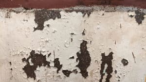
Using the results of the paint analysis and paint stripper tests, OnAim applied CitriStrip to remove the top white layer of paint that had been sealing the map. This process consisted of first allowing a 3”x 3” (76 x 76mm) thick layer of citrus strip to sit on the paint layer for an average of 15 minutes. After an allotted time, a scalpel was utilised to carefully scrape away the white layer. OnAim then used a #0000 steel wool pad soaked in an aqueous solution of Dawn to neutralise the stripper and gently scrub away leftover residue, any remaining paint then being scraped away with a scalpel. This method proved to be the best to ensure that a minimal part of the original layers would be compromised. Rust blooms and other structurally-compromising issues throughout the mural were addressed at this time.
Once the remainder of the map was exposed, it was thoroughly cleaned with an aqueous solution of Dawn and then the mural was documented in detail. Damar varnish was applied to the entire surface to protect this original layer.
Findings
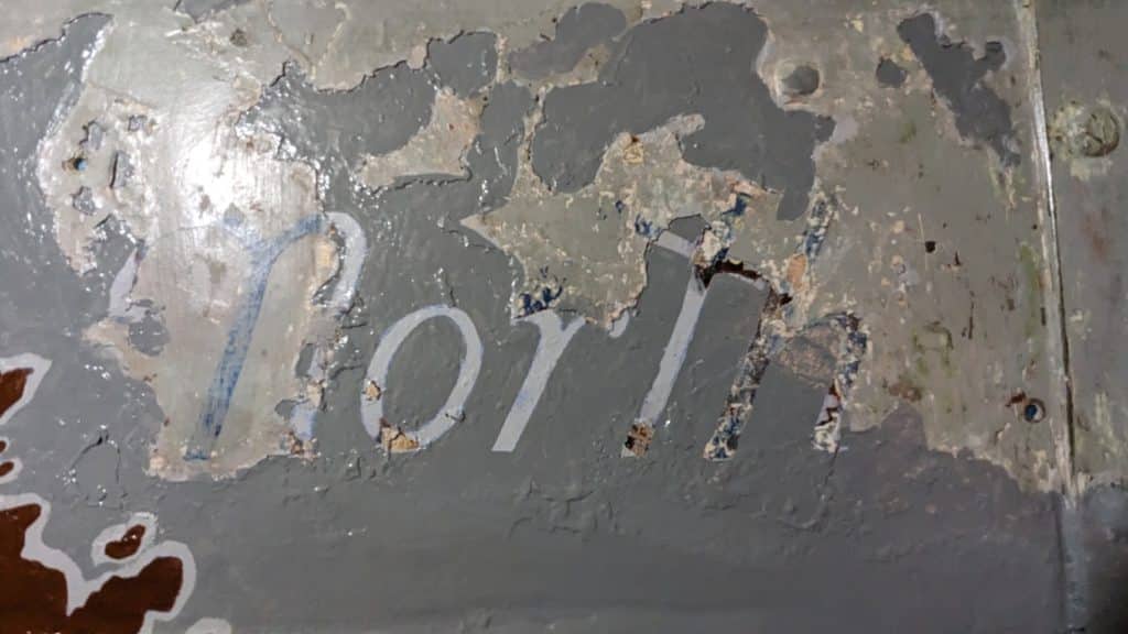
OnAim was able to uncover quite a bit of the original map, with really only the cut-out window and any heat-damaged metal parts being areas that were a complete loss. “While the reveal itself was amazing, there were two unique findings that altered our expectations of what the final map would look like,” says Roesch. One was the surprising find of lettering on the left panel just above where the window was cut.
Starting with an ‘N’ and ending in ‘h’, it was clear that it said ‘North’. “After some research, we found that most maps read North Atlantic Ocean when looking at Earth with just this section showing,” explains Zak Miano. “Anything north of the equator is considered North Atlantic, and looking at the USS Texas map, the floor is just a bit further south than the equator. After discussing the addition with TPWD and The Battleship Texas Foundation, all parties agreed that ‘Atlantic Ocean’ should be added.”
OnAim began testing two adhesives and their compatibility with a methylene chloride base paint stripper using paint chip samples acquired from the map. The B-72 adhesive solution and PC universal glue adhesives were graded on their evaporation rate and overall quality. During testing, the B-72 adhesive reacted adversely with the base paint stripper and resulted in an undesirable high evaporation rate, whereas the PC universal glue had no adverse reactions with the paint stripper and showed a low evaporation rate which would provide ample work time. OnAim concluded that the PC universal glue yielded the best results and was chosen as the desired adhesive for the procedure.
OnAim removed the protective wood frame from the wall to begin applying the PC universal glue to the flaking paint layers of the map. The process began by diluting the glue in distilled water and applying the solution between the cracks of the flaking paint surface using a small paintbrush. Larger paint flakes were treated using a monojet syringe to apply the solution behind the paint. Any excess glue was removed by blotting the surface with a damp rag. OnAim then used a heated tacking iron (between 250-300°F) to set and adhere the flaking paint flat onto the surface. To prevent the adhesive from sticking to the iron and pulling paint, silicone relief paper was placed between iron and paint. This process was repeated until the surface was fully consolidated.
After the adhesive cured, the map wall was cleaned with a solution containing 50ml of distilled water and 5ml of Vulpex museum-grade liquid soap. It was applied using a clean rag then wiped down with distilled water between each scrubbing. The sections of the map that were visible (top right corner) were cleaned with extra precaution to avoid removing any of its parts. Once the surface was fully clean and dry, OnAim applied two coats of a varnishing solution containing 25ml of satin Damar varnish and 5ml of distilled turpentine to the visible sections of the map and the compass rose (bottom right section), using a natural hair oil brush to seal the surface and create a sacrificial layer.
As part of this first phase of stabilising the Atlantic theatre map, OnAim conducted various tests to prepare for the following two phases: a paint removal analysis to decide on the best type of product for the chemical removal of the top layer of paint that is overlaying the map, and a paint analysis conducted by Ignite Diagnostic Solutions LLC to identify the original colours used on the map and compare them to the 1939 Navy paint formulas to see which was the closest match.
Chemical paint removal analysis:
“Due to the age of the paint and possible chemical makeup, we were thinking that only a chemical stripper containing methylene chloride would yield the desired results since it is easily controlled and has a shorter wait time,” explains Ariane Roesch, who with her husband Zak Miano, owns OnAim Conservation. “We tested three commonly bought paint strippers (see attached chemical paint removal analysis) to remove paint on the Atlantic theatre map: CitriStrip, Klean Strip, Strypeeze (with methylene chloride), and 100% methylene chloride. Out of all, the CitriStrip gave the best results due to its non-toxic gelatinous nature that works well on vertical surfaces, plus its easy clean-up using mineral spirits, soap and water. Since it is non-toxic it also does not need a well-ventilated room, making it easier to environmentally-control the space. A thick layer has to be applied for it to work.”
Paint sample analysis:
Ignite Diagnostic Solutions removed a variety of paint chips to analyse, each with about 14 layers of paint. Under OnAim’s directive, the goal was to analyse not only the abundant ‘green’ paint, but primarily the ‘red’ paint used to demarcate land masses on the map, as well as the ‘blue-grey’ paint that demarcated the water.
Based on the 1939 Navy paint formula library, the ‘red’ paint sample matched most closely with the red lead formula, matching the makeup of the paint suppliers National Starch and Goodrich. The ‘green’ sample (middle layer) most closely matched the ‘semi-flat’ formula. Based on the data, it was concluded that the ‘green’ sample (top layer) matched the ‘light green gloss’ formula, and the ‘green sample’ (bottom layer) matched the ‘green motor boat’ formula. The ‘blue-grey’ sample matched the ‘blue stripping paint’ formula.
Phase II: Paint removal
Using the results of the paint analysis and paint stripper tests, OnAim applied CitriStrip to remove the top white layer of paint that had been sealing the map. This process consisted of first allowing a 3”x 3” (76 x 76mm) thick layer of citrus strip to sit on the paint layer for an average of 15 minutes. After an allotted time, a scalpel was utilised to carefully scrape away the white layer. OnAim then used a #0000 steel wool pad soaked in an aqueous solution of Dawn to neutralise the stripper and gently scrub away leftover residue, any remaining paint then being scraped away with a scalpel. This method proved to be the best to ensure that a minimal part of the original layers would be compromised. Rust blooms and other structurally-compromising issues throughout the mural were addressed at this time.
Once the remainder of the map was exposed, it was thoroughly cleaned with an aqueous solution of Dawn and then the mural was documented in detail. Damar varnish was applied to the entire surface to protect this original layer.
Findings
OnAim was able to uncover quite a bit of the original map, with really only the cut-out window and any heat-damaged metal parts being areas that were a complete loss. “While the reveal itself was amazing, there were two unique findings that altered our expectations of what the final map would look like,” says Roesch. One was the surprising find of lettering on the left panel just above where the window was cut.
Starting with an ‘N’ and ending in ‘h’, it was clear that it said ‘North’. “After some research, we found that most maps read North Atlantic Ocean when looking at Earth with just this section showing,” explains Zak Miano. “Anything north of the equator is considered North Atlantic, and looking at the USS Texas map, the floor is just a bit further south than the equator. After discussing the addition with TPWD and The Battleship Texas Foundation, all parties agreed that ‘Atlantic Ocean’ should be added.”
 “The other find was the state of Texas, in an orange hue, superimposed over Africa with the compass rose situated over the Panhandle and West Texas,” explains Roesch. “While parts of the compass rose were already exposed and one could see a faint outline of Africa before stripping the top white layer, there had been no indication that Texas was somehow incorporated on the map.”
 Phase III: Restoration
The third and final phase was to restore the map through paint infill, using the newly unearthed original parts as guides to complete the full map, as well as historical maps of that era to assist with layout and content.
OnAim subcontracted Kati Ozanic, a local painter, teacher, and artistic director who has experience painting murals and could work within the confined area, to transcribe the missing parts of the map.
“OnAim and The Battleship Texas Foundation agreed that the paint infill should be done in such a way as to tell the story of the map, memorialise the actions that were taken, and not obscure what had occurred,” says Miano. “It was decided that anything that is added should match in colour to the original but would be set apart by having a smooth newly-painted appearance. Using the ship’s paint index from 1939, colours were matched and tinted accordingly. For example, the US east coast, which was completely lost due to the bulkhead viewing window being cut out, would be painted using a brown that matched the colour of the original land masses but would stand out due to its smooth, non-cracked appearance.”
Kati Ozanic started by tracing all unveiled land masses on tracing paper. Using that as a reference, she tried to match it with various projections of maps. Judging by the expanding grid pattern painted along the edge, the original artist seemed to have had experience in maps and navigation. They had painted the map with an eye towards perspective and curvature of the globe. “This is why the land masses up top, like Canada, seem to be more stretched out and areas along the bottom, like Africa, seem to be more compact,” says Roesch.
Referencing the historical photo from 1966 and using both projections and visual artistic interpretation, Ozanic was able to finalise the land masses on the tracing paper. This tracing was then transferred onto the bulkhead using Saral transfer paper. Once transferred and outlined, areas were then painted in.
“The next step was to label the capitals, ports, and areas of interest, as well as mark any points of conflict with an explosion – just as things were demarcated on the original map,” says Miano. Using a tracing of the existing lettering, research was done regarding font type and size. OnAim settled on the American Type Founders (ATF) collection based on the map’s timeframe and considering what type of font would have been widely available. ATF Alternate Gothic was used for labelling all cities and areas (32pt height, 25pt kerning). The first letters of ‘North Atlantic Ocean’ most closely matched and are based on the ATF Livermore Script font. The remaining letters were created based on the forms of the original lettering on ‘North’.
Using the existing delineations on the compass rose, the missing parts were added and painted. The gradations per quadrant, as is faintly evident in the historical photo, are based on the various brown tones used in the map’s land masses. The light switch to the right had originally been painted a brown to blend in with the mural’s land masses. The metal housing was removed, cleaned, and stripped of existing paint before painting it again using the same colour as was used on the land masses.
Paint and varnish details
OnAim utilised the 1941 ship colour swatches provided by the Battleship Texas Foundation to colour-match the colours used in the map painting. All exposed steel was first primed using Sherwin-Williams Rust Beater red oxide primer. “We used Sherwin-Williams All Surface Enamel for the topcoat,” says Roesch. “While the colour-matched paint was close to the original colours, a Mixol tint system was used to tint them to be a closer match.”
OnAim used Damar varnish for a sacrificial sealant as well as a sealant tint. With a variation of grey, green, ochre, and yellow oxide tints in Damar varnish, OnAim used these for the dual purpose of sealing and ‘ageing’ the new paint so that the aesthetic differences between old and new were not too stark. That was then allowed to dry and then finally a clear coat of Damar varnish was applied to the whole of the painting. Damar varnish was used because it is both durable and easily reversible.
Whilst the stabilisation and conservation of the map has been completed, the restoration of the ‘superdreadnought’ USS Texas continues apace at Gulf Copper.
Phase III: Restoration
The third and final phase was to restore the map through paint infill, using the newly unearthed original parts as guides to complete the full map, as well as historical maps of that era to assist with layout and content.
OnAim subcontracted Kati Ozanic, a local painter, teacher, and artistic director who has experience painting murals and could work within the confined area, to transcribe the missing parts of the map.
“OnAim and The Battleship Texas Foundation agreed that the paint infill should be done in such a way as to tell the story of the map, memorialise the actions that were taken, and not obscure what had occurred,” says Miano. “It was decided that anything that is added should match in colour to the original but would be set apart by having a smooth newly-painted appearance. Using the ship’s paint index from 1939, colours were matched and tinted accordingly. For example, the US east coast, which was completely lost due to the bulkhead viewing window being cut out, would be painted using a brown that matched the colour of the original land masses but would stand out due to its smooth, non-cracked appearance.”
Kati Ozanic started by tracing all unveiled land masses on tracing paper. Using that as a reference, she tried to match it with various projections of maps. Judging by the expanding grid pattern painted along the edge, the original artist seemed to have had experience in maps and navigation. They had painted the map with an eye towards perspective and curvature of the globe. “This is why the land masses up top, like Canada, seem to be more stretched out and areas along the bottom, like Africa, seem to be more compact,” says Roesch.
Referencing the historical photo from 1966 and using both projections and visual artistic interpretation, Ozanic was able to finalise the land masses on the tracing paper. This tracing was then transferred onto the bulkhead using Saral transfer paper. Once transferred and outlined, areas were then painted in.
“The next step was to label the capitals, ports, and areas of interest, as well as mark any points of conflict with an explosion – just as things were demarcated on the original map,” says Miano. Using a tracing of the existing lettering, research was done regarding font type and size. OnAim settled on the American Type Founders (ATF) collection based on the map’s timeframe and considering what type of font would have been widely available. ATF Alternate Gothic was used for labelling all cities and areas (32pt height, 25pt kerning). The first letters of ‘North Atlantic Ocean’ most closely matched and are based on the ATF Livermore Script font. The remaining letters were created based on the forms of the original lettering on ‘North’.
Using the existing delineations on the compass rose, the missing parts were added and painted. The gradations per quadrant, as is faintly evident in the historical photo, are based on the various brown tones used in the map’s land masses. The light switch to the right had originally been painted a brown to blend in with the mural’s land masses. The metal housing was removed, cleaned, and stripped of existing paint before painting it again using the same colour as was used on the land masses.
Paint and varnish details
OnAim utilised the 1941 ship colour swatches provided by the Battleship Texas Foundation to colour-match the colours used in the map painting. All exposed steel was first primed using Sherwin-Williams Rust Beater red oxide primer. “We used Sherwin-Williams All Surface Enamel for the topcoat,” says Roesch. “While the colour-matched paint was close to the original colours, a Mixol tint system was used to tint them to be a closer match.”
OnAim used Damar varnish for a sacrificial sealant as well as a sealant tint. With a variation of grey, green, ochre, and yellow oxide tints in Damar varnish, OnAim used these for the dual purpose of sealing and ‘ageing’ the new paint so that the aesthetic differences between old and new were not too stark. That was then allowed to dry and then finally a clear coat of Damar varnish was applied to the whole of the painting. Damar varnish was used because it is both durable and easily reversible.
Whilst the stabilisation and conservation of the map has been completed, the restoration of the ‘superdreadnought’ USS Texas continues apace at Gulf Copper.
 Read more articles like this in the latest issue of Protective Coatings Expert
Further information about OnAim Conservation can be found here
Read more articles like this in the latest issue of Protective Coatings Expert
Further information about OnAim Conservation can be found here
The approximately 8ft x 8ft (2.4 x 2.4m) map of the WWII Atlantic theatre was painted on a bulkhead in the captain’s cabin after September 1944 (based on references in the map). It shows the ports of call USS Texas made during WWII (white dots with anchors in them), where she performed shore bombardment (noted by little explosions), national capitals (yellow triangles), and a few surprise discoveries as the map was conserved.
Some time after 1966, which is when the only known historic photo of the map was taken, the map, along with the rest of the captain’s cabin, was painted white. That act was not great, but not terrible either. What was truly terrible is that a window was cut into the bulkhead right in the middle of the map some time in the late 1970s, after the map and compartment were painted white. The Battleship Texas Foundation believes that because the map had been painted over and knowledge of the map lost, those who made that decision did not know it was there.
The only known historic photo of the map
OnAim began testing two adhesives and their compatibility with a methylene chloride base paint stripper using paint chip samples acquired from the map. The B-72 adhesive solution and PC universal glue adhesives were graded on their evaporation rate and overall quality. During testing, the B-72 adhesive reacted adversely with the base paint stripper and resulted in an undesirable high evaporation rate, whereas the PC universal glue had no adverse reactions with the paint stripper and showed a low evaporation rate which would provide ample work time. OnAim concluded that the PC universal glue yielded the best results and was chosen as the desired adhesive for the procedure.
OnAim removed the protective wood frame from the wall to begin applying the PC universal glue to the flaking paint layers of the map. The process began by diluting the glue in distilled water and applying the solution between the cracks of the flaking paint surface using a small paintbrush. Larger paint flakes were treated using a monojet syringe to apply the solution behind the paint. Any excess glue was removed by blotting the surface with a damp rag. OnAim then used a heated tacking iron (between 250-300°F) to set and adhere the flaking paint flat onto the surface. To prevent the adhesive from sticking to the iron and pulling paint, silicone relief paper was placed between iron and paint. This process was repeated until the surface was fully consolidated.
After the adhesive cured, the map wall was cleaned with a solution containing 50ml of distilled water and 5ml of Vulpex museum-grade liquid soap. It was applied using a clean rag then wiped down with distilled water between each scrubbing. The sections of the map that were visible (top right corner) were cleaned with extra precaution to avoid removing any of its parts. Once the surface was fully clean and dry, OnAim applied two coats of a varnishing solution containing 25ml of satin Damar varnish and 5ml of distilled turpentine to the visible sections of the map and the compass rose (bottom right section), using a natural hair oil brush to seal the surface and create a sacrificial layer.
As part of this first phase of stabilising the Atlantic theatre map, OnAim conducted various tests to prepare for the following two phases: a paint removal analysis to decide on the best type of product for the chemical removal of the top layer of paint that is overlaying the map, and a paint analysis conducted by Ignite Diagnostic Solutions LLC to identify the original colours used on the map and compare them to the 1939 Navy paint formulas to see which was the closest match.
Chemical paint removal analysis:
“Due to the age of the paint and possible chemical makeup, we were thinking that only a chemical stripper containing methylene chloride would yield the desired results since it is easily controlled and has a shorter wait time,” explains Ariane Roesch, who with her husband Zak Miano, owns OnAim Conservation. “We tested three commonly bought paint strippers (see attached chemical paint removal analysis) to remove paint on the Atlantic theatre map: CitriStrip, Klean Strip, Strypeeze (with methylene chloride), and 100% methylene chloride. Out of all, the CitriStrip gave the best results due to its non-toxic gelatinous nature that works well on vertical surfaces, plus its easy clean-up using mineral spirits, soap and water. Since it is non-toxic it also does not need a well-ventilated room, making it easier to environmentally-control the space. A thick layer has to be applied for it to work.”
Paint sample analysis:
Ignite Diagnostic Solutions removed a variety of paint chips to analyse, each with about 14 layers of paint. Under OnAim’s directive, the goal was to analyse not only the abundant ‘green’ paint, but primarily the ‘red’ paint used to demarcate land masses on the map, as well as the ‘blue-grey’ paint that demarcated the water.
Based on the 1939 Navy paint formula library, the ‘red’ paint sample matched most closely with the red lead formula, matching the makeup of the paint suppliers National Starch and Goodrich. The ‘green’ sample (middle layer) most closely matched the ‘semi-flat’ formula. Based on the data, it was concluded that the ‘green’ sample (top layer) matched the ‘light green gloss’ formula, and the ‘green sample’ (bottom layer) matched the ‘green motor boat’ formula. The ‘blue-grey’ sample matched the ‘blue stripping paint’ formula.
Phase II: Paint removal
Using the results of the paint analysis and paint stripper tests, OnAim applied CitriStrip to remove the top white layer of paint that had been sealing the map. This process consisted of first allowing a 3”x 3” (76 x 76mm) thick layer of citrus strip to sit on the paint layer for an average of 15 minutes. After an allotted time, a scalpel was utilised to carefully scrape away the white layer. OnAim then used a #0000 steel wool pad soaked in an aqueous solution of Dawn to neutralise the stripper and gently scrub away leftover residue, any remaining paint then being scraped away with a scalpel. This method proved to be the best to ensure that a minimal part of the original layers would be compromised. Rust blooms and other structurally-compromising issues throughout the mural were addressed at this time.
Once the remainder of the map was exposed, it was thoroughly cleaned with an aqueous solution of Dawn and then the mural was documented in detail. Damar varnish was applied to the entire surface to protect this original layer.
Findings
OnAim was able to uncover quite a bit of the original map, with really only the cut-out window and any heat-damaged metal parts being areas that were a complete loss. “While the reveal itself was amazing, there were two unique findings that altered our expectations of what the final map would look like,” says Roesch. One was the surprising find of lettering on the left panel just above where the window was cut.
Starting with an ‘N’ and ending in ‘h’, it was clear that it said ‘North’. “After some research, we found that most maps read North Atlantic Ocean when looking at Earth with just this section showing,” explains Zak Miano. “Anything north of the equator is considered North Atlantic, and looking at the USS Texas map, the floor is just a bit further south than the equator. After discussing the addition with TPWD and The Battleship Texas Foundation, all parties agreed that ‘Atlantic Ocean’ should be added.”
Starting with an ‘N’ and ending in ‘h’, it was clear that it said ‘North’
The state of Texas, in an orange hue, superimposed over Africa
The restoration nears completion
x150(h)")


